


Les deux lacs

lorenzot54
User
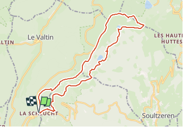

Length
19 km

Max alt
1300 m

Uphill gradient
724 m
Km-Effort
29 km

Min alt
1045 m

Downhill gradient
723 m
Boucle
Yes
Creation date :
2023-12-14 19:43:51.0
Updated on :
2023-12-14 19:43:54.574

FREE GPS app for hiking
 SityTrail
IGN / Geographical institutes
SityTrail Plus
The world is yours!
About
Trail of 19 km to be discovered at Grand Est, Vosges, Le Valtin. This trail is proposed by lorenzot54.
Description
La Schlucht, Tanet, lac vert, lac des Truites retour gazon de Faing
Positioning
Country:
France
Region :
Grand Est
Department/Province :
Vosges
Municipality :
Le Valtin
Location:
Unknown
Start:(Dec)
Start:(UTM)
352684 ; 5325319 (32U) N.
Comments